Find an office location
More than 175 offices from coast to coast.
Want to know what is below the ground? Drill a boring. Geotechnical exploration has taken that approach for hundreds of years. But this approach has its disadvantages, the most significant one being the fact that we don’t really know what is between the borings. And what you don’t know can be a big issue when it comes to construction of foundations.
Advancements in technology now provide us a great supplement to the traditional soil boring. Using nonintrusive, geophysical techniques, Terracon can help you understand much more about the subsurface, particularly the variations that occur between soil borings. And these methods are minimally disruptive, fast and, thorough.
Geophysical techniques can be used to locate buried objects, chart underground utilities, map faults, and variations in below grade conditions like depth to bedrock. These techniques also help us understand the constructed environment, for example, we can determine the foundation characteristics of large structures such as deep foundations and dams.
The explosion of technology and data processing capability has allowed dramatic increases in the resolution of geophysical instrumentation. But the growth of these revolutionary capabilities is restricted by three things:
Geotechnical engineers and geologists have great confidence in a myriad of methods to explore the subsurface with tools that collect samples and allow us to visually see, feel and perform tests on samples from the subsurface. Our confidence quickly wanes with nonintrusive, geophysical methods.
The geophysicist plays a critical role in the larger team that is tasked with characterizing the subsurface. Terracon has over 25 geophysicists across the nation, and we work with our geologists and geotechnical engineers on a daily basis. This deliberate effort to incorporate geophysical tools into traditional exploration is allowing Terracon to create that heightened awareness that is so critical to the proper incorporation of geophysics in projects.
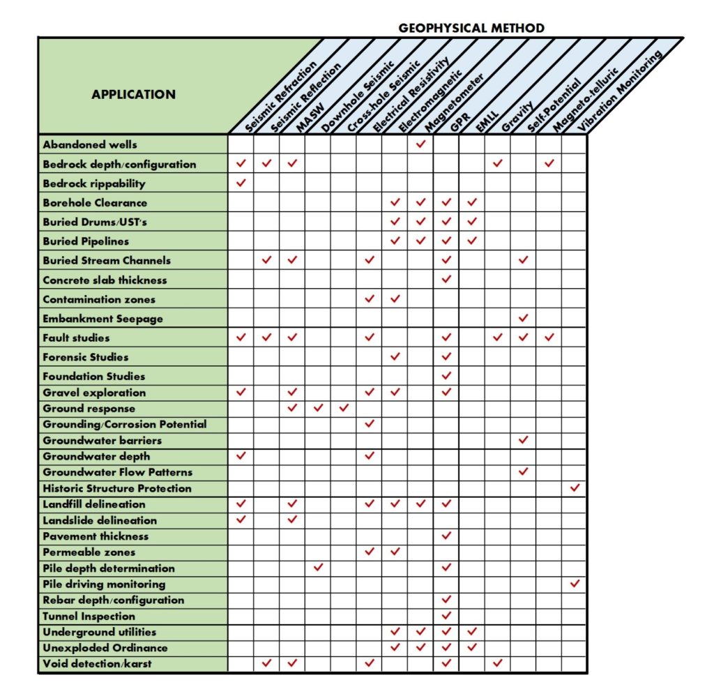
Geophysical tools help us measure physical properties of the earth such as electrical resistivity, vibrations, variations in sound wave velocity, magnetism and gravitational fields. All of these properties, and especially the variation of these properties, can give us an understanding of the subsurface soil, groundwater and rock conditions. The complexity and diversity of geophysical methods often creates a challenge in determining which method is right for investigating the subsurface conditions of each unique site. Factors to be considered include site surface conditions, the desired depth of investigation, and the local geology. Terracon has developed a table which we refer to as a Geophysical Matrix. This table is intended to be a guide for the proper use and application of geophysical methods. It was created to illustrate the:
The left column of the Matrix indicates 32 possible applications and the top row lists the fourteen most commonly used geophysical methods that can be employed for these applications. The check marks in the matrix cells indicate which methods are most appropriate for each application. In some cases multiple methods may be advisable.
The Geophysical Matrix is shown below:

The massive amount of data that can be collected from the various geophysical tools are impressive. Advanced computer software now provides ways to compose colorful data summaries that basically lump together similar properties as recorded by the field instruments and visually display anomalies. At first glance the data appear to show obvious features.
However, understanding what this data means for a particular project needs is a critical responsibility that should be entrusted only to trained geophysicists who have experience in the specific geologic setting and with the specific needs of the project. Terracon’s team of geophysicists, geologists and geotechnical engineers work interactively to see below the ground with all that tools that we need.
Terracon can assist clients with complex subsurface investigations using advanced geophysical techniques. Our knowledge, experience and expertise allow us to provide clients with a unique perspective on which geophysical methods are available and which are most suitable for their unique site. For more information on the use of geophysics contact a Terracon geophysics professional near you
Bill Black is a Senior Geophysicist with Terracon. He has over 40 years of experience in the conduct of geophysical investigations for projects across the nation. Bill has pioneered the advancement of geophysical methods to determine subsurface characteristics for geotechnical, water resources and environmental applications.
More than 175 offices from coast to coast.